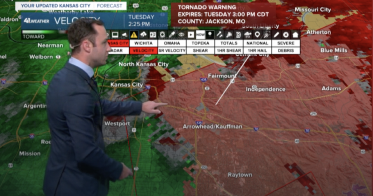
Kansas City and the surrounding areas are currently facing severe weather conditions, with parts of Cass, Jackson, and Johnson counties under a tornado warning. The National Weather Service (NWS) issued this warning as they track a potent weather system bringing the potential for tornadoes, severe thunderstorms, and flooding.
On this rainy Tuesday, activity in the atmosphere has heightened. The severe weather in the Kansas City area is expected to manifest in various forms, including thunderstorms that could deliver wind gusts of up to 70 mph. These conditions have prompted a tornado watch effective until 8 p.m. local time, alerting residents to remain vigilant and prepared.
As the situation evolves, the NWS has also issued flash flood warnings until Wednesday morning for several counties in the vicinity, including Cass, Clay, Jackson in Missouri, and Johnson, Miami, Leavenworth, and Wyandotte in Kansas. The blend of heavy rainfall and potential tornado formations creates a precarious environment for those in the affected regions.
Today at approximately 2:31 p.m., the NWS indicated a tornado was likely forming near the Truman Sports Complex, which intersects Interstate 435 and Highway I-70. This announcement heightens the urgency for residents to stay informed and take necessary precautions. The tornado warning initially filed for southeastern Clay, southwestern Ray, and other central counties, including Jackson and Johnson, is set to expire shortly, but it demonstrates the nature of these weather events—dynamic and unpredictable.
Live updates from the NWS underscore the active nature of the storms. At 2:19 p.m., a severe thunderstorm warning was issued for various areas across Kansas City, acknowledging the 70 mph wind gusts and heavy rains accompanying the storm. The need for vigilance and readiness cannot be overstated.
Moreover, with multiple counties experiencing severe weather warnings, it is crucial for residents to remain informed. The latest radar updates and weather forecasts can help families and individuals prepare appropriately. A severe thunderstorm warning alongside tornado watches creates a situation where community members must heed weather alerts and follow guidelines set by local officials.
As the sky darkens and anticipation builds, communities across Cass County, Johnson County, and other areas are encouraged to create safety plans. This includes securing properties and reviewing emergency kits. Staying updated through reliable resources like KSHB 41 will provide crucial information as the weather develops.
At around 1:47 p.m., the NWS raised warnings for northwestern Miami County and southwestern Johnson County, showcasing their commitment to timely communication with the public. While some warnings may expire, it is imperative to remain on high alert as new updates stream in. As these weather systems move, conditions can rapidly change; what seems calm can become dangerously severe in moments.
The tornado warnings, alongside flash flood warnings, constitute a multifaceted challenge for the region. The safety of families and homes should always remain the top priority. Residents are reminded to move to sturdy shelters if they find themselves under any of these warnings. It’s a time to come together, support one another, and focus on safety.
In preparation for such extreme weather events, local authorities remind everyone to have plans in place. Families should have emergency contacts, a designated meeting place, and supplies in readiness. Developing these protocols can make a significant difference in times of crisis.
As of this writing, the severe weather continues to be monitored closely. As updates flow in, residents should check reliable news sources and official channels like the NWS to obtain real-time information. The unpredictable nature of such storms underscores the importance of being prepared and remaining alert, not just today but as we move through the storm season in the months ahead.
The shared experience of facing severe weather has a way of bringing communities together. In times of uncertainty, neighbors often lend a helping hand—whether assisting with securing outdoor spaces or sharing resources such as food and shelter. Emphasizing collective responsibility can help everyone navigate through challenging moments effectively.
In summary, the risk of tornadoes, severe thunderstorms, and flooding around Cass, Jackson, and Johnson counties calls for immediate attention. If you’re in these areas, please stay tuned to local alerts and take the proper cautious actions for your safety. Remember to check the latest KSHB 41 weather updates for the most accurate information and forecasts. Weather patterns can change rapidly, and being informed is your best defense against nature’s unpredictable fury. Whether from a trusted weather app, a local news station, or community announcements, real-time updates are essential in these critical hours. Stay safe, Kansas City.
Source link


,autocrop(1200:630)&w=150&resize=150,100&ssl=1)

